Flying drones on Svalbard#
As mentioned in the second session on UAV pre-flight check list, whenever you design a flight plan, you have to know and comply with specific UAV operation laws in the area you are flying.
In Svalbard, the drone regulations are defined by the Governor of Svalbard according to the Norwegian Civil Aviation Authority, which supersedes any information on this page.
Per 1. January 2025, these regulations state:
Drones are prohibited in all protected areas in Svalbard, and it is not allowed to disturb wildlife.
This means that special permits are needed in all protected areas around Svalbard, including its many nature reserves and national parks. Furthermore, special rules and regulations exist that extend to the filming and photography from the air, for which Norway’s National Security Authority and the Norwegian Data Protection Authority hold a final say (and provide information). Read more here and here
Do not disturb the wildlife
It is forbidden to disturb the wildlife on Svalbard. This includes flyind drones around bird cliffs and nesting areas, marine and terrestrial mammals, etc.
Do not fly without permission
It is prohibited to fly in many areas around Svalbard. This typically does not rule out the use of UAVs in its entirety, but rather that exceptions must be sought prior to operations.
Avinor IIPC (Air navigation services)
Longyearbyen#
Around Longyearbyen it is not permitted to fly drones closer than 5 km to the airport, unless permission from the control tower has been granted. The pilot must obtain permission himself for each flight.
Fig. 20 Map around Longyearbyen where flying drones is prohibited. You can open the map following this link.#
Ny-Alesund#
Flying drones is prohibited in Ny-Alesund and the entire Kongsfjorden due to the flying ban of five kilometers around Ny-Alesund airport and the 20 km radio silence zone around the city. The Norwegian Communications Authority is responsible for managing frequency resources in Norway.
Kings Bay A/S owns Ny-Alesund Airport and is formally responsible for the airspace in the Hamnerabben Traffic Information Zone (red line on map).
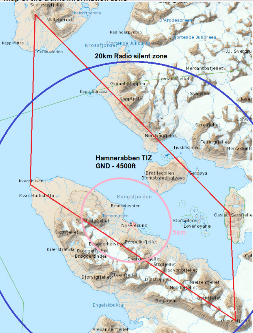
Fig. 21 Traffic information zone (red line on map) established to protect the airspace around the airport and the flights to and from the airport.#
Hamnerabben Traffic Information Zone
For more information regarding the Hamnerabben Traffic Information Zone and the Ny-Alsund area, click here.