
Exercise 3 - Plan your UAV-based data acquisition survey#
It is now up to you to acquire your own data in the field. As discussed in previous sessions, the success of a data acquisition campaign depends greatly on survey planning.
The focus of this session is to plan and prepare everything that is needed for a UAV-based acquisition survey.
Assignment#
The well-known riverbed outcrop in Todalen is missing in the Svalbox DOM database.
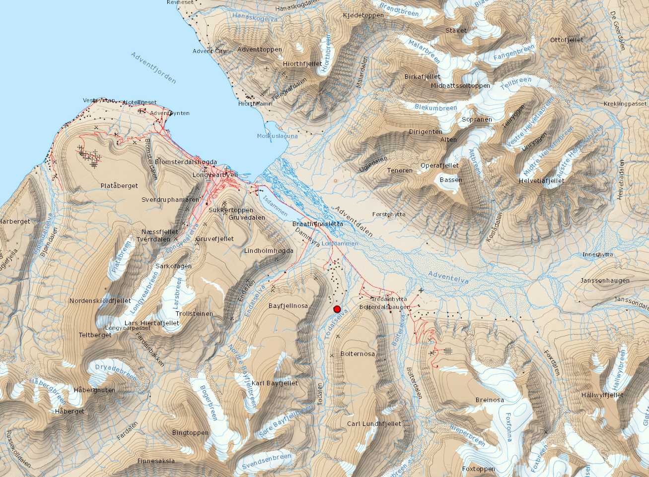
Fig. 3 The red dot shows the location of the outcrop. Approximate coordinates:#
UTM: 33X E519671 N8677658
DD.DDDDD: 78.17154°N 15.85968°E
DD MM.MMM: 78°10.292'N 15°51.581'E
DD MM SS.S: 78°10'17.5"N 15°51'34.8"E
You need to work in pairs to create an acquisition survey that will gather the most accurate data possible from this location in order to produce a digital outcrop model.
Equipment
Each group will have the following equipment:
1 UAV (to choose between: DJI Mavic Mini 2, DJI Mavic 2 Air, DJI Mavic 2 Pro, DJI Phantom)
3 batteries per group
Remote controller
Memory card
To design your flight plan and focus on the outcrop, take advantage of online resources. The AG-222 Compendium provides an extensive list of datasets and online resources that can be helpful to you.
Questions to ask yourself while planning a UAV acquisition survey
What is the (geological) interest/purpose of the DOM?
What factors should you consider before acquiring the data? (e.g. scale, resolution, precision requirements?)
What resources (e.g. batteries) do I have?
What limitations are present and what should I expect?
What flight pattern will I follow?
What camera timelapse will I use?
When are the best light conditions during the day? Should I expect many shadows in the outcrop?
What weaknesses does the acquisition survey have?
Equipment and software check#
Make sure that all your batteries are charged, memory card empty, you have all software updates, etc.
Pre-flight check list#
At the very least, the following information needs to be completed before going to the field.
crew:
    pilot:
    pilot_license:
    co-pilot:
    co-pilot_license:
    visual_observer1:
    visual_observer1_license:

flight:
    date:  # in DD/MM/YYYY
    location: # Where do you find your outcrop target?
    land: # PICK: Albert I Land / Andrée Land / Bünsow Land / Dickson Land / Haakon VII Land / Heer Land / James I Land / Nathorst Land / Nordenskiöld Land / Ny-Friesland / Olav V Land / Oscar II Land / Sabine Land / Sørkapp Land / Torell Land / Wedel Jarlsberg Land / Gustav Adolf Land / Gustav V Land / Orvin Land
    island:  # PICK: Hopen / Spitsbergen / Kong Karls Land / Edgeøya / Barentsøya / Tusenøyane / Nordaustlandet / Kvitøya / Prins Karls Forland / Bjørnøya / Other
    flight_description:  # Add a brief description of flight objectives

uav:
    uav_id:
    uav_model:  # brand and model of the UAV
    uav_insurance:

documentation:
    documentation:  # Additional authorisations (if required)

weather_info:  # to be filled in the field
    cloud_cover:  # % of cloud cover
    temperature:  # in degrees Celsius
    wind_direction:
    wind_speed:  # in m/s
    visibility:  # in m
    precipitation:  # yes/no
Now you are ready to fly. Enjoy your flight, and always fly safely and considerately!